Same Day, Same City, Different Experiences

Spokane, Wash. – The Gonzaga Center for Climate, Society, and the Environment’s newest project takes a close look at the impact of extreme heat events in Spokane. The project began after the 2021 heat dome took the lives of 20 community members in Spokane, and more than 800 regionally. After a summer of hard work, initial findings have arrived at the Gonzaga Climate Center.
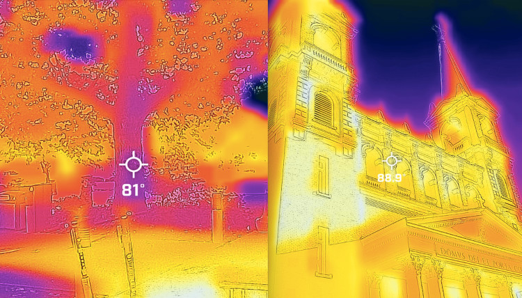
The Gonzaga Climate Center led a unique partnership that included city government (Spokane City Council’s Sustainability Action Subcommittee), news media (KXLY’s Chief Meteorologist, Kris Crocker), and environmental non-profits (The Lands Council and 350 Spokane). On July 16, 2022, 40 local volunteers attached sensitive instruments to their vehicles and gathered more than 43,000 measurements related to location, temperature, and humidity. The aim of the community science project was to measure differences in temperature caused by the “urban heat island effect” or the intensification of urban heat due to less green space and tree canopy and darker surfaces.
According to the National Weather Service in Spokane, the official high temperature for July 16 as registered at Spokane International Airport was 88 degrees Fahrenheit. However, according to the data collected, the high temperature in Spokane proper was 94.1 degrees Fahrenheit, registered at the Safeway at W. Northwest Boulevard and N. Maple Street.
The most important finding of the Gonzaga Climate Center heat study is evidence confirming what many have long thought: some Spokane neighborhoods are much warmer than others. This study demonstrates that, at its most extreme, on the same day, two different neighborhoods can differ in temperature by as much as 13.9 degrees. And neighborhoods that aren’t that far apart can show some dramatically different temperatures at the same time. During the 3-4 pm hour July 16, the tree-lined streets of the Manito neighborhood registered a temperature of 85.2 degrees Fahrenheit, while the West Central neighborhood three miles away, with considerably less green space, registered at 93.8 degrees Fahrenheit.
These temperature differentials are the direct result of the urban heat island effect. This effect shows how urban environments can both mitigate or exacerbate the impacts of high temperatures. Areas with increased canopy cover (trees) and green space do not experience extreme heat to the same degree as urban spaces with little vegetation, clustered buildings, and sprawling dark surfaces.
Gonzaga senior Ben Brown, who has been helping with the Spokane Beat the Heat program, an initiative to help the community understand and deal with the impacts of extreme summer heat, was encouraged by the findings.
“Having this dataset in my hands feels really empowering. Not only did the community come together to collect this vital information, but the end product is easy to understand, share, and utilize,” said Brown, an Environmental Studies and Economics double major. “With it, we can reach so many people with concrete information and begin to set change in motion.
“It’s easy to get lost in the dire warnings of warming trends around the world. However, receiving these results and working on Spokane Beat the Heat inspires hope that we meaningfully work towards equity and community resilience in the face of the climate crisis,” Brown added.
The work was supported by a grant from the National Oceanic Atmospheric Administration, NOAA, and in collaboration with CAPA Strategies, a firm specializing in climate analytics and planning. The data collected by community volunteers were sent back to CAPA to be analyzed and have now been returned in the form of heat maps, displaying differences in temperature between areas of Spokane.
For project partner Rebecca MacMullan, a co-founder of the climate action group 350 Spokane, the heat maps couldn’t have come at a better time.
“Spokane's deadly heat wave in 2021 revealed an urgent need for high-quality data on how heat is distributed across the city,” said MacMullan. “This eye-opening study can help Spokane build community resilience and prepare for extreme heat with a focus on neighborhoods that face the highest risk.”
That might mean creating a future heat action plan that could involve the creation of a network of cooling shelters, targeted urban tree planting and an education program to teach people the dangers of extreme heat exposure.
The Gonzaga Climate Center did not rest on its laurels after July’s heat mapping campaign, however. The Climate Center’s Spokane Beat the Heat program quickly entered a second phase with a community-wide survey of experiences and perceptions of extreme heat.
There is growing optimism that with the complementary data sets, the Gonzaga Climate Center can work with City partners at multiple levels to help improve extreme heat planning.
“Data from Gonzaga’s Beat the Heat program will help Spokane be better prepared for future extreme heat events and take adaptive measures to support those most at risk from heat exposure,” said Kara Odegard, Sustainability Manager for Spokane City Council. “This work will save lives.”
The Gonzaga Center for Climate, Society, and the Environment will continue taking responses to their extreme heat survey over the coming months. After taking the time to understand the results, Spokane Beat the Heat will forge on with its community partners to stop preventable loss of life due to extreme heat and build a more resilient community, equipped to handle the challenges of the 21st century.